
Wondering where to go hiking in Hong Kong? Ascend these trails for jaw-dropping views and a good challenge!
Whether you like hitting the best beaches, trying out different water sports, or checking out islands around Hong Kong, there’s no denying it: there are so many fun activities that you can do outdoors in the 852. And one of our favourite ways to de-stress and relax on the weekend is to go hiking in Hong Kong. So, we’ve put together a list of the best hiking trails for all ages and levels. Be sure to pack plenty of water before you head out on your adventure!
Best hiking trails in Hong Kong for all levels
For beginners: Easy hikes in Hong Kong
1. Ping Shan Heritage Trail
A flat, urban trail focused on cultural heritage, suitable for all fitness levels.

For the history buffs who love hiking in Hong Kong, head on down to the city’s first-ever heritage trail: Ping Shan Heritage Trail. There are lots of walking and much to take in, including the 200-year-old walled villages of Hang Tau Tsuen and Hang Mei Tsuen. Featuring historic buildings belonging to the Tangs, the most well-known of the “Five Clans”, the trail includes Hong Kong’s oldest pagoda – Tsui Sing Lau Pagoda – as well as the magnificent Tang Clan Ancestral Hall and the Ping Shan Tang Clan Gallery.
Distance: Approximately 1.6 km
How to get to Ping Shan Heritage Trail: Ride the Tuen Ma Line to Tin Shui Wai MTR Station. The beginning of the trail is right beyond Exit D. Alternatively, bus 969 can also take you from Causeway Bay to Tin Shui Wai. Alight at Tin Fuk Road and walk 100 m to reach the start of the trail, marked by the Tsui Sing Lau Pagoda.
Learn more about the Ping Shan Heritage Trail online.
2. Lung Ha Wan Country Trail
A coastal trail with gentle slopes and scenic views; great for beginners.

Find yourself caught up in the beauty of Clearwater Bay as you hike along the Lung Ha Wan Country Trail. Located within Clearwater Bay Country Park, the trail is incredibly family-friendly as it’s very accessible. Being an easy hike in Hong Kong, Lung Ha Wan is quite popular among families with young children. You’ll come across plenty of scenic views along the way, like sea caves and nearby islands. You can even bring your own kite to fly!
Distance: Approximately 2.3 km
How to get to Lung Ha Wan Country Trail: Ride the MTR to Diamond Hill Station and take Exit D1. Then, hop on bus 91 at Diamond Hill Plaza Hollywood and alight at Clearwater Bay Second Beach.
Learn more about Clearwater Bay Country Park online.
3. High Island Geo Trail
A flat, well-paved trail with stunning geological formations, suitable for all fitness levels.

Not up for tackling the tough sections of the MacLehose Trail? Then the High Island Geo Trail is an ideal hiking destination for you. Begin your journey at the High Island Reservoir East Dam and hike through Biu Tsim Kok to reach the hexagonal volcanic rock formations. The Geo Trail concludes at a sea cave on the Sai Kung coast. Showcasing fascinating natural wonders unique to the area, the trek will be well worth it for beginners and families!
Distance: Approximately 3.4 km
How to get to High Island Geo Trail: Take bus 92 from Diamond Hill MTR Station Exit C2 and alight at Sai Kung Town Centre. From Sai Kung, take minibus 9A and alight at High Island Reservoir East Dam.
Learn more about High Island Geo Trail online.
4. Thousand Island Lake
A scenic hike with some uphill climbs and rocky terrain, but manageable for most hikers.

Also known as Tai Lam Chung Reservoir, located within Tai Lam Country Park, Thousand Island Lake is undoubtedly one of the most photographed hikes in Hong Kong. On a clear, sunny day, try capturing the reflection of the sky on the reservoir, with islands scattered around – it’s a priceless sight you need to see in person! The majority of the trail is well-paved, shaded, and flat.
Distance: Approximately 3.9 km
How to get to Thousand Island Lake: Catch minibus 43 from Tuen Mun and alight at So Kwun Wat village. Follow the signpost for MacLehose trail.
Learn more about Tai Lam Country Park online.
5. Kam Shan Country Park (Monkey Hill)
A family-friendly trail with gentle slopes, ideal for leisurely walks and monkey spotting.

Want an easy hike and to see some wild monkeys? Explore the Kam Shan Country Park (aka Monkey Hill) to encounter many monkeys along the way – but beware that these animals will attack and steal, if they smell any traces of food on you! There are many path links on the Kam Shan Family Walk and Kam Shan Tree Walk, including ones that lead to the small Kam Shan Valley and others to the Shing Mun Valley.
Distance: Approximately 3.4 km
How to get to Kam Shan Family Walk: Take the MTR to Cheung Sha Wan Station and use exit A1. Then, get on bus 72 to the Shek Lei Pui Reservoir.
Learn more about Kam Shan Country Park online.
6. Cape D’Aguilar
A coastal trail with mostly flat terrain and scenic views; great for beginners.

Prepare to venture into caves, hike up to a historic lighthouse, and find the skeletal remains of a killer whale, all while basking in the beautiful views. Cape D’Aguilar is more of a walk than a hike, but if you want to find a sweet spot to chill on top of the rocks, minor clambering is involved.
Distance: Approximately 8 km
How to get to Cape D’Aguilar: Get on bus 9 from Sau Kei Wan and alight at Cape D’Aguilar (name of the stop itself). Head straight after getting off.
7. The Peak Trail
A well-paved and gentle trail around Victoria Peak, suitable for all fitness levels.

Amidst the city’s lush verdure and craggy hilltops, an hour before dusk is the perfect time to head to the summit of The Peak. On arrival, hikers will get to see a hundred million bright city lights start to twinkle in the city below.
A hit with the locals and tourists alike, The Peak Trail is a walking trail designed for both exercise and educational attainment offering hikers with a better knowledge of the surrounding ecology with signs and boards explaining the flora that you may come across during your walk – ideal to keep the little ones entertained. And of course, there’s lots to rejoice over once you reach The Peak too!
Distance: Approximately 4 km
How to get to The Peak Trail: Take bus 13 from Central to Kotewall Road to start the hike at Hatton Road.
Learn more about the nature walks at The Peak online.
8. Tung O Ancient Trail
A flat, historic trail connecting Tung Chung and Tai O; suitable for beginners.

Leading from Tung Chung to Tai O, Tung O Ancient Trail is a rather long but not too complicated trail – great for families who love hiking in Hong Kong! The trail offers an array of fascinating things to check out during the hike, including Hau Wong Temple that is built in 1765, beautiful Stilt Houses, Tai O Heritage Hotel, and the Northwest Lantau Coast, so you won’t get bored.
Distance: Approximately 15 km
How to get to Tung O Ancient Trail: Take the MTR to Tung Chung Station and use Exit B. Then, hop on bus 3M, 11, 23, or 34 at Tung Chung Bus Terminus. Get off at Ha Ling Pei and walk to Tung Chung Fort.
Moderate hikes in Hong Kong
9. Lion Rock
Steep sections and some rocky terrain, but well-marked and popular.

This one serves as symbolism to Hong Kong, perhaps it’s the lion spirit. The Lion Rock hike starts off quite easy but the final ascent is the toughest, with steep steps that seem never-ending. But you know what they say: the toughest climbs lead to the most beautiful views, and Lion Rock is no less. Get a bird’s eye, panoramic view of Kowloon and all its glory.
Distance: Approximately 6 km
How to get to Lion Rock: Take minibus 18M from Wong Tai Sin and alight at Temple Hill Fat Jong Temple. Finally, walk uphill to the entrance of Lion Rock Country Park.
Learn more about Lion Rock Country Park online.
10. Tate’s Cairn (Tai Lo Shan)
A mix of uphill climbs and well-paved paths, suitable for intermediate hikers.

This moderate hike is a unique trail in Hong Kong, with views of Kowloon on one side and Sai Kung on the other. Tate’s Cairn, or Tai Lo Shan, is a very open trail that is not crowded by many trees, but surrounds hikers with outlooks of tall mountain ranges in Hong Kong. The trail acts as both a hiking trail and a car path, so beware of any passing vehicles when you hike.
Distance: Approximately 3.9 km
How to get to Tate’s Cairn: Ride the MTR to Diamond Hill Station and take Exit C.
11. Devil’s Peak
Short but steep sections with historical interest; manageable for most hikers.

Despite the intimidating name, this trail is not all too difficult and strenuous. There really is just one steep step of stairs and that’s it. Sure enough, the summit offers stunning sea views, but the real picturesque part of this hike comes from Gough Battery. Feel like an explorer going past historical remnants occupied by pirates as a hideout spot and the British for military purposes.
Distance: Approximately 3 km
How to get to Devil’s Peak: From Yau Tong MTR Station, you can get to the starting point on foot. From Domain Mall, exit to Ko Chiu Road, then walk towards Lei Yue Mun Estate. Walk up Tseung Kwan O Chinese Permanent Cemetery until you reach the entrance to Wilson Trail. Finally, follow the signposting for Devil’s Peak.
12. Yuen Tsuen Ancient Trail
A long trail with some uphill sections, but well-maintained and scenic.

If you fancy a nice long trail for hiking in Hong Kong, try Yuen Tsuen Ancient Trail. Used to be an essential path for people to go from Tsuen Wan to Yuen Long, Yuen Tsuen Ancient Trail is a hidden treasure where you can check out the harbour channels around Tsuen Wan and Tsing Yi, as well as Tsing Ma Bridge and Ting Kau Bridge. In the middle of the hike, you’ll come across Tin Fu Tsai Campsite, where you can take a rest and devour your packed lunch.
Distance: Approximately 12.5 km
How to get to Yuen Tsuen Ancient Trail: Take minibus 84 at Tsuen Wan MTR Station to Allway Gardens.
Learn more about Yuen Tsuen Ancient Trail online.
13. Wu Kau Tang Country Trail
A mix of flat and hilly terrain, passing through villages and forests.

Start your hike at Wu Kau Tang Village, and on the way find yourself walking by small village houses and in a large forest that is home to many birds and wildlife. This hike is great in the summer, as trees cover the path, providing a lot of shade and a stream nearby that keeps the path cool. The end of the trail lies an abandoned Hakka Village, a hidden cultural gem in Hong Kong.
Distance: Approximately 2.4 km
How to get to Wu Kau Tang Country Trail: Ride the MTR to Tai Po Market Station and take Exit B. Hop on bus 20R to Wu Kau Tang.
Learn more about Wu Kau Tang Country Trail online.
14. High Junk Peak Country Trail
A mix of uphill climbs and rocky sections, but shorter and less intense than some of the tougher trails.

While being one of the three sharpest summits in Hong Kong, the High Junk Peak Country Trail is a relatively moderate path. When sitting on the peak, you get to overlook the entire Clearwater Bay as well as the neighbouring golf course. If climbing onto the very top scares you, you have the option to walk past it and still enjoy splendid views. It’s also a great idea to visit the oldest Tin Hau Temple near the entrance to the country park.
Distance: Approximately 8.5 km
How to get to High Junk Peak Country Trail: Go to Exit C2 of Diamond Hill MTR Station and ride bus 91 to Ng Fai Tin.
Learn more about High Junk Peak Country Trail online.
15. Needle Hill (Cham Shan)
A steep climb with stairs and rocky sections, but relatively short and manageable for intermediate hikers.

Are you up for yet another one of the three sharpest peaks in Hong Kong? Sharp like a needle (where it gets its name), Needle Hill’s trail is sandwiched between Tsuen Wan and Sha Tin. You can expect there to be plenty of ups and downs throughout the hike. Once you reach the summit, enjoy the beautiful vista of Shing Mun Reservoir – you might even be able to see all the way to Lion Rock on a bright and clear day!
Distance: Approximately 12 km
How to get to Needle Hill: Take minibus 82 from Tsuen Wan MTR Station to reach Shing Mun Reservoir and walk to the main dam.
16. Pineapple Mountain (Por Lo Shan)
Features some steep and uneven sections, but is shorter in distance.

Did you know Hong Kong has its very own mini Grand Canyon in the New Territories? The best timing to be at Pineapple Mountain (aka Pineapple Hill or Por Lo Shan) has to be during sunset when the unique rock formations glimmer in shades of warm yellow. Since the trail doesn’t have much of a paved path, we strongly recommend wearing suitable hiking shoes.
Distance: Approximately 6 km
How to get to Pineapple Mountain: From Siu Hong Light Rail Station, take the Light Rail train 615 or 505 to Leung King Station. Next, cross the tracks to Leung King Plaza, walk past Sai Wan Court and Leung Wai House. Finally, follow the trail uphill to Leung Tin Au.

17. Jardine’s Lookout
A steep climb with rewarding views, suitable for intermediate hikers.

A moderate hike with rewarding panoramic views of Hong Kong’s islands, Jardine’s Lookout is accessible and connects to other picturesque hikes (like Mount Butler and Braemar Hill) nearby. This hike starts with a slightly steep incline, but it’s manageable. Unlike many other hikes, you can’t admire the view on your way to the top as the bushes are pretty tall, but that also means more shade and less sun!
Distance: Approximately 4 km
How to get to Jardine’s Lookout: Head to Wong Nai Chung Reservoir Park and walk toward Tai Tam Reservoir Road. Follow the signposting that says Wilson Trail Section 2.
18. Ap Lei Pai
A coastal hike with some rocky and uneven terrain, but relatively short.

Despite its proximity to the city, the rugged trail connecting Yuk Kwai Shan and Ap Lei Pai feels like a remote island getaway, rewarding hikers with striking ocean views and a scenic red lighthouse. Though short in distance, the hike packs a punch with steep inclines that are sure to get your heart racing. Come prepared with proper footwear, ample water, and snacks – the terrain is by no means easy, with loose rocks and gravel underfoot. But, the challenging trek is worth it for the breathtaking coastal views and sense of adventure.
Distance: Approximately 4 km
How to get to Ap Lei Pai: Ride the MTR to Lei Tung Station and take Exit B to get to Lei Tung Estate Road. Then, walk towards a small side path up to Lee Nam Road until you reach Ap Lei Chau Service Reservoir. Finally, follow the fence and go up the stairs to access the Mount Johnston Trail.
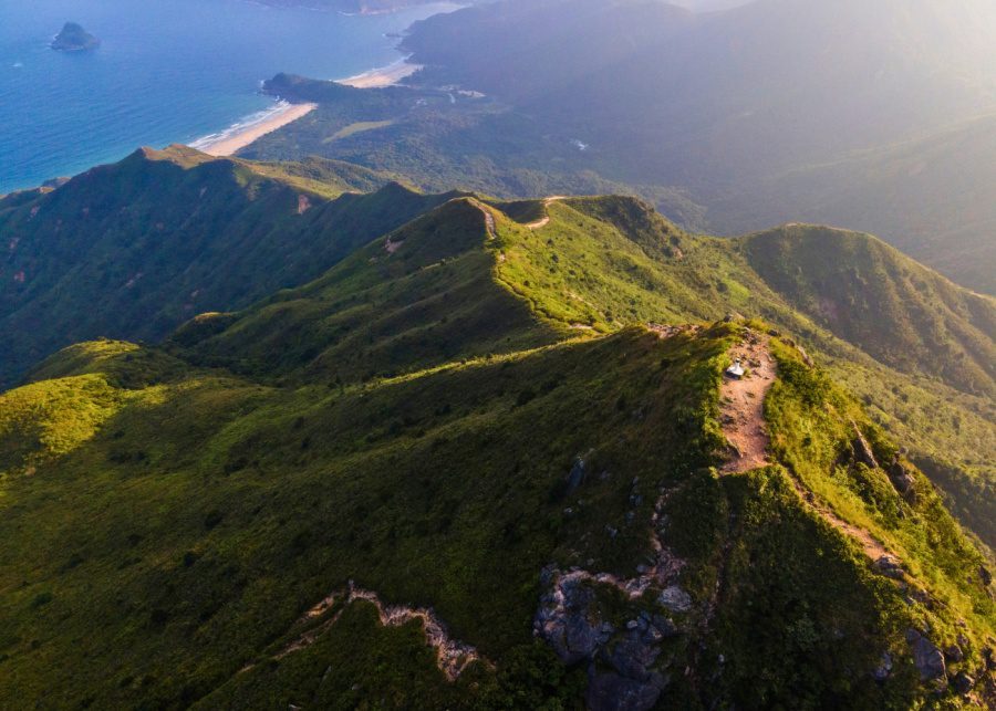
19. Dragon’s Back
A popular trail with rolling hills and scenic views, suitable for intermediate hikers.

One of Hong Kong’s most iconic and popular trails is Dragon’s Back. It’s even been hailed by Time Magazine as Asia’s best urban hike! The Dragon Back hike takes you on a breezy path through shady groves of bamboo and lush woodland, accompanied by fluttering butterflies and the soothing sounds of birds. It finally emerges into open hillsides covered with wild azaleas or rose myrtle.
A lot of hikers come to a small mountain gap high up on the Dragon’s Back to fly kites or jump off into the great blue yonder with paragliding wings – perfect for the adrenalin junkies out there. If you’re wondering where to go hiking in Hong Kong, then this is the place to start.
Distance: Approximately 8.5 km
How to get to Dragon’s Back: Take the MTR to Shau Kei Wan Station and use Exit A to get to Shau Kei Wan Bus Terminus. Next, hop on bus 9 or the minibus with the sign “Shek O” next to the bus terminus. Lastly, alight at To Tei Wan, Shek O Road.
20. Po Toi Country Trail
A mix of coastal and uphill sections, with some rocky terrain, but manageable for most hikers.

The Po Toi Country Trail is a challenging multistage trail that passes through the beautiful landscape of Hong Kong’s southernmost island. Hiking up even a small segment of this mountain provides breathtaking scenery. You’ll witness the most beautiful rock formations as you walk across Cheung Shek Pai, where a series of gigantic rocks forms a natural track. Most notably, you’ll find yourself in awe at the two most recognisable landmarks of Po Toi: the gigantic palm and a huge tortoise making its way uphill – both naturally carved on these cliffs by the elements of nature!
Distance: Approximately 4 km
How to get to Po Toi Country Trail? Board a kaito (small ferry) at Aberdeen Pier. The journey takes around an hour. This kaito service operates every day (including public holidays), except Mondays, Wednesdays, and Fridays.
21. Finger Hill
A short but steep hike on Lantau Island, offering panoramic views.

Located on the quiet island of Peng Chau, the hike up Finger Hill is suitable for all levels, and is the perfect walk for the entire family to enjoy. Hike through beautiful forest for just 45 minutes and then reach the seating are with stunning views of Disneyland and Tsing Ma Bridge. Don’t forget to pack your camera for this one!
Distance: 7 km
How to get to Finger Hill? Follow the signs from Peng Chau ferry terminal.
22. Ngong Ping 360 Rescue Trail
A steep and narrow trail used for cable car maintenance, requiring some effort but not overly long.

You may have been on the Ngong Ping, but how about hiking just beneath to follow the path to the Big Buddha? Unlike the other trails, Ngong Ping 360 Rescue Trail (aka Ngong Ping Trail) has strong wooden planks throughout – and did we mention you’ll be hiking right underneath cable cars? While the trail isn’t too difficult, it has plenty of steps. There’s no shade either, so coat your skin with enough sunscreen.
Distance: Approximately 5.7 km
How to get to Ngong Ping 360 Rescue Trail: After getting off at Tung Chung MTR Station, walk past Yat Tung Estate to Tung O Ancient Trail. Another 10-minute walk and the trail’s starting point will be on your left.
Learn more about Ngong Ping Trail online.
23. Ling Kok Shan
A scenic trail with some uphill sections and rocky terrain; suitable for intermediate hikers.

Hiking the Ling Kok Shan trail from Sok Kwu Wan on Lamma Island is the perfect way to work up an appetite for seafood or work off a big lunch. The paved path features striking rock formations and dazzling ocean views along the way. Mid-hike, be ready for a thigh-burning stair climb over 200 m up to the peak. However, the views from the top make it all worthwhile. The moderately difficult uphill will get your heart pumping, too. Thankfully, the steep stairs are interspersed with beautiful lookout points for you to catch your breath.
Distance: Approximately 5.3 km
How to get to Ling Kok Shan: Take the ferry to Sok Kwu Wan on Lamma Island. Then, walk along the main street and start taking the trail up the hill at the century-old Tin Hau Temple.
Pros only! Hardest hikes in Hong Kong
24. Kowloon Peak (Fei Ngo Shan)
Steep ascents and challenging terrain, especially near the summit.

As the highest peak in Kowloon (therefore aka Kowloon Peak), Fei Ngo Shan is definitely one of the most popular hiking spots in Hong Kong. The first part of the trail is beginner-friendly, with no steep slopes and rocky paths. However, it gets challenging if you decide to head to Suicide Cliff, where fatal accidents have occurred when people over-estimated their physical ability. The upside is the stunning views you get over Kowloon and Hong Kong Island when you reach the top. The trail from Fei Ngo Shan to Suicide Cliff is also a popular night hike.
Distance: Approximately 6.8 km
How to get to Kowloon Peak: Walk along Clearwater Bay Road from Exit B of Choi Hung MTR Station. After you arrive at the bottom of the hill, head left on Fei Ngo Shan Road.
25. Pat Sin Leng
A challenging ridge hike with steep ascents and descents, requiring good fitness.

Known for its steep elevations and winding paths, Pat Sin Leng (aka Ridge of the Eight Immortals) is suitable for advanced and experienced hikers. Going across the eight summits of the mountain range, this hike takes you through the Pat Sin Leng Country Park, a scenic park that’s often shrouded in mystical white clouds and mist. Below your feet, you’ll find sweeping views of Tai Po, set alongside plunging valleys and vast green plains.
Distance: Approximately 11 km
How to get to Pat Sin Leng: Take the MTR to Fanling Station and hop on minibus 52B from Exit A3. Alight at the last stop, Hok Tau. Alternatively, take the MTR to Tai Wo Station for Wilson Trail Section 8. This leads you through the Pat Sin Leng Country Park.
Learn more about Pat Sin Leng Country Park online.
26. MacLehose Trail
A long-distance trail with varying difficulty; some sections are extremely challenging, especially Stages 3, 4, and 8.

Whether you are an earth-science fanatic, professional photographer, or the super-adventurous type with a “never-say-no” spirit, you’ll marvel at the some of the world’s most magnificent geological sites and breathtaking beaches on the MacLehose Trail. Begin with some fun cliff-jumping at Sheung Luk Stream – just don’t forget to pack your swimsuit and take caution! However, it’s the Sai Kung section of this enjoyable trail that deserves a mention, with its stunning sea caves, sea stacks, hexagonal columns, and dykes.
Distance: Approximately 100 km, with 10 sections
How to get to MacLehose Trail: Take the MTR to Diamond Hill Station and take Exit C2. Hop on bus 92 to Sai Kung Town.
27. Tai Mo Shan Trail
The highest peak in Hong Kong, with a mix of paved paths and steep sections. Weather conditions can add to the difficulty.

Adventurous hikers, this one’s for you! The Tai Mo Shan Trail is incredibly challenging and we only recommend it to advanced hikers who often go hiking in Hong Kong. There are many sections in the trail, each leading to different places in the area. Climb one of the highest mountains in Hong Kong – Tai Mo Shan – which gives an absolutely gorgeous view of the city. Another attraction is the Lead Mine Pass, hidden deep within the forest. You’ll also encounter centuries-old abandoned mines along the way. We suggest taking the routes to Shing Mun Reservoir, as it’s a great spot to take in the scenery and enjoy a well-deserved lunch.
Distance: Approximately 11 km
How to get to Tai Mo Shan Trail: Take the MTR to Tsuen Wan Station and take Exit A. Then, get on bus 51 and alight at Country Park Station.
28. Suicide Cliff
A steep and challenging hike with exposed sections and loose rocks, requiring good fitness and experience.

Thrill-seekers will want to add Suicide Cliff to their Hong Kong hiking bucket list for its breathtaking views and heart-pumping challenge. Located in Sai Kung Country Park, it takes hikers up a steep and narrow path to a lofty cliff edge, overlooking the turquoise waters below. Reach the cliff top at 469 m for exhilarating panoramas that explain this trail’s daring name. While the exposure may not be for the faint-hearted, safety precautions like tagging along with experienced climbers can minimise the risks on this route.
Distance: Approximately 1.3 km
How to get to Suicide Cliff: Take minibus 1A from Choi Hung MTR Station Exit C1 and alight at Fei Ngo Shan Road. Next, walk along the road until a small and winding path appears on your left, just before some residences. This path marks the start of the route up to the cliff overlook.
29. Sharp Peak Hiking Trail
Known as one of the most challenging hikes in Hong Kong, with steep ascents and descents, and exposed ridges.
Sharp Peak Hiking Trail is a challenging trail that sits inside Sai Kung East Country Park. It takes you to stunning beaches where you can play on the soft sands without being disturbed. However, since it is literally a sharp peak 468 m above sea level, expect yourself to be climbing up and crawling down for some parts. A pair of hiking shoes will give you a better grip on the loose soil.
Distance: Approximately 12 km
How to get to Sharp Peak Hiking Trail: Hop on bus 94 at the Sai Kung Bus Terminus and get off at Pak Tam Au. On weekends and public holidays, you can also take bus 96R from Diamond Hill MTR Station or bus 289R from Sha Tin MTR Station. Again, alight at Pak Tam Au.
30. Kai Kung Leng (Rooster Ridge)
A demanding hike with steep ascents, exposed ridges, and challenging terrain, often requiring scrambling.

We believe Kai Kung Leng is an underrated and less traversed hike in Hong Kong, so we wouldn’t be surprised if you’ve never heard of it, not to mention it’s all the way near the Chinese border. Before you venture out, apply ample sunscreen; you may even want to carry some along, as this hike barely has any shade (we recommend going in winter). When the weather is very humid, the clouds may even lower down and level with the summit. The summit of Kai Kung Leng offers a stunning view of Nam Sang Wai; further away, you can even see the skyline of Shenzhen, stretching all the way to Nanshan.
Distance: Approximately 7.5 km
How to get to Kai Kung Leng: Take minibus 603 from Yuen Long MTR Station and get off at Fung Kat Heung Road. Take the path by the electric pole on the left.
31. The Twins
Known for its infamous “1,000 steps,” this trail is steep and physically demanding.

You may have heard of the notorious Twins; yes, the hike doesn’t have a great reputation given the endless stairs, but it’s an awesome workout and ends by the beach, so it’s all worth it! You can hike around Violet Hill (which is more of a breeze), then continue onto The Twins to get to Stanley and cool off. If you love a good challenge, you’ll love this hike.
Distance: Approximately 4.8 km
How to get to The Twins: Get to Wong Nai Chung Reservoir Park and walk up to Tai Tam Reservoir Road. The trail starts at Wilson Trail Section 1.
Learn more about Wilson Trail Section 1 online.
32. Lantau Trail
A long-distance trail with varying difficulty; sections like Lantau Peak are particularly challenging.

Hiking the Lantau Trail is a fantastic way to experience the natural beauty and cultural heritage of Lantau Island. Whether you’re looking for a challenging climb or a leisurely walk, this trail has something for everyone! With 12 sections, the trail begins at Mui Wo (Silvermine Bay) and ends at Tai O, but it can be accessed from multiple points. Two of the highlights along the trail are Sunset Peak (Section 2) and Lantau Peak (Section 8), which offer breathtaking views during golden hour. Though the latter takes an arduous climb to get to, the panoramic views from the summit will be well worth the effort.
Distance: Approximately 70 km, with 12 sections
How to get to Lantau Trail: At Tung Chung MTR Station, get on bus 3M and alight at Pak Kung Au.
A final note: Spending time outside is also a great way to reconnect us with nature. Just don’t forget to pack your sunscreen and loads of water!
FAQs about hiking in Hong Kong
Is it safe to hike alone in Hong Kong?
While Hong Kong is known to be one of the safest places on Earth, hiking alone, as with any outdoor activity, can be risky. That being said, solo hiking in Hong Kong can be safe as long as you take the necessary precautions. Here are some tips to help ensure your safety:
- Planning ahead: Research the trail you plan to hike, including the difficulty level, length, and terrain. Make sure to inform someone about your hiking plans, including your expected return time.
- Stay on designated trails: Stick to marked trails and avoid taking shortcuts or straying off the path to prevent getting lost.
- Check the weather: Hong Kong's weather can change quickly, and typhoons or heavy rain can make trails dangerous. So, always check the weather forecast before heading out.
- Bring sufficient supplies: Carry enough water, snacks, a fully charged phone, a map or GPS device, a first aid kit, and any other necessary equipment for the hike.
- Dress appropriately: Wear suitable clothing and footwear for the terrain and weather conditions. It's a good idea to layer clothing for changing weather.
- Stay alert: Be mindful of your surroundings, watch out for wildlife (especially snakes and wild boars in Hong Kong), and stay on the lookout for any potential hazards on the trail.
- Know your limits: Don't push yourself too hard. If you feel tired or unwell, it's better to turn back.
- Emergency numbers: Familiarise yourself with local emergency numbers. In Hong Kong, you can call 999 for police, fire, or ambulance services.
What is the hardest hike in Hong Kong?
The hardest hike in Hong Kong is often considered to be the MacLehose Trail Section 4, which includes the ascent of Ma On Shan and Pyramid Hill. This section is known for its steep climbs, rugged terrain, and challenging elevation changes.
Sections 3 and 8 of the MacLehose Trail are also strong contenders for being the most challenging hikes in Hong Kong, along with the Twin Peaks in Wilson Trail Section 3, Lantau Peak, and Tai Mo Shan.
What are the "Big Four" hikes in Hong Kong?
The "Big Four" hikes in Hong Kong are the Hong Kong Trail, Lantau Trail, MacLehose Trail, and Wilson Trail.
Is Hong Kong good for hiking?
Hong Kong is a fantastic destination for hiking, offering a wide range of trails that cater to hikers of all levels. Many hiking trails in Hong Kong are easily accessible from urban areas, making it convenient for both locals and tourists to immerse themselves in nature without having to travel far from the city centre. Along the way, hikers can enjoy scenic views and diverse terrain, as well as cultural and historic sites. Also, Hong Kong's hiking trails are well-marked and well-maintained, making it easier for travellers to navigate the trails and enjoy a safe and comfortable experience.
