Immerse yourself in nature and work up a sweat at the best places to hike in Singapore.
It’s easy to go hiking in Singapore. We’re always out and about, exploring lush parks in Singapore, nature reserves, and secret spots over the weekend. From forested hills to scenic coastal paths, we love putting on our adventure caps for a green escape. Being one with nature totally helps lower our stress levels. Simply swap the city bustle for fresh air at these places to hike in Singapore!
Where to go hiking in Singapore: Easy walking trails
1. Sungei Buloh Wetland Reserve

For an immersive, calming nature experience, make your way to the first wetland reserve and ASEAN Heritage Park in Singapore. We love Sungei Buloh Wetland Reserve’s peaceful trails and curious array of flora and fauna – we’ve spotted animals like monitor lizards, estuarine crocodiles, and smooth-coated otters on our multiple visits!
Birdwatching enthusiasts, check out the 1.95km Migratory Bird Trail to see herons, kingfishers and sunbirds. Meanwhile, the 3km Mangrove Boardwalk offers sightings of mudskippers, mud lobsters and crabs. Families can try the 1.3km Coastal Trail to admire waterfront views from scenic pitstops like Eagle Point or Kingfisher Pod.
Best for: Wildlife sightings and coastal trails
Park size: 202 hectares
Difficulty level: Easy
Sights to look out for: Eagle Point, Kingfisher Pod, wildlife sightings
How to get there: Sungei Buloh Wetland Reserve’s centre is located at 301 Neo Tiew Crescent
2. Labrador Nature Reserve

We’ll let you in on a little secret: Labrador Nature Reserve is one of our go-to parks for quiet me-time or outdoor dates. Its trails are some of Singapore’s most picturesque seaside ones, offering sweeping views of the coastline, cliff sides, and marshes. That’s why it’s a favourite for fishing enthusiasts and families hosting BBQ gatherings.
The new 340m Keppel Coast Trail is a short stroll, so we’d recommend heading to the 2.1km Labrador Nature & Coastal Walk instead. We love exploring the mangroves at Berlayer Creek and spotting Reflections at Keppel Bay and Sentosa from the Bukit Chermin Boardwalk.
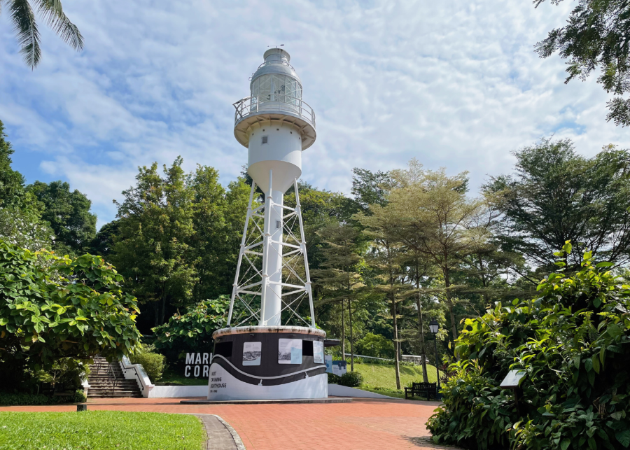
Tip: venture deeper into the greenery to see WWII relics and replicas. If you didn’t know, the area was formerly a coastal artillery fort for the British. Oh, and keep an eye out for the red Berlayer Point Lighthouse and the Dragon’s Teeth Gate, a leftover granite outcrop that once stood in the mouth of Keppel Harbour.
Best for: Quiet, calming seaside strolls
Park size: 22 hectares
Difficulty level: Easy
Sights to look out for: Dragon’s Teeth Gate, war relics
How to get there: Labrador Nature Reserve is located along Labrador Villa Road
3. Rower’s Bay Park
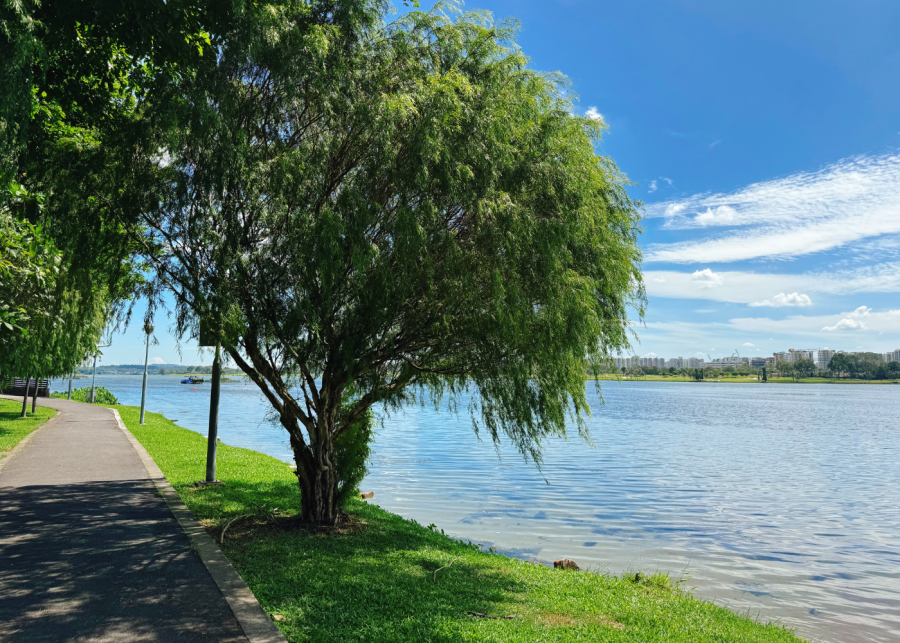
Okay, Rower’s Bay Park is more of an easy, short walk, but if you love exploring underrated nature places, don’t ignore this sleepy park connector that’s located at the end of Lower Seletar Reservoir, next to Yishun Dam. On our weekend afternoon visit, the tranquil spot was peppered with a handful of people fishing, lying on the grass in the shade, and taking a slow stroll along the boardwalk by the water to spot the turtles. P.S. it’s a great place to watch the sunset!
Best for: A relaxed stroll by the water
Park size: 1.5 hectares
Difficulty level: Easy
Sights to look out for: The boardwalk, the wetland, and native wildlife
How to get there: Rower’s Bay Park is located along Seletar Club Road
4. Bishan-Ang Mo Kio Park

Hit up the heartlands to hike Bishan-Ang Mo Kio Park, one of the largest urban parks in central Singapore. First opened in 1988 and revamped in 2012, it’s a go-to spot for families and outdoor lovers. We’ve spotted people jogging, cycling, doing tai chi, practising yoga, and taking their pup for a stroll here.
It’s easy to spend one to two hours exploring the park’s naturalised river, three playgrounds, therapeutic garden, lotus garden, and more. After soaking up the sun, refuel at Grub Pasta Kitchen. Need extra R&R? Treat yourself to a pampering session at Aramsa – The Garden Spa. It’s our idea of the perfect day out!
Best for: Leisurely fun for the entire family
Park size: 62 hectares
Difficulty level: Easy
Sights to look out for: Water playgrounds, a therapeutic garden, and the occasional otter appearance
How to get there: Bishan-Ang Mo Kio Park is located along Bishan Road and Ang Mo Kio Avenue 1
5. Jurong Lake Gardens

Jurong Lake Gardens, the pride of the west, is a stunner! If you’re travelling from afar, we recommend you dedicate an entire afternoon to exploring it – that’s what we did. The revamped Chinese and Japanese Gardens are home to the Twin Pagodas, Cloud Pagoda, Grand Arch and Bonsai Garden, as well as the Floral Garden, Moon Terraces, and Water Lily Garden, respectively. We loved taking our time to gaze at the gorgeous architecture.
Oh, and the sprawling Lakeside Garden is perfect for families, nature lovers, and weekend wanderers, with its water play area at Clusia Cove, Forest Ramble playgarden, and skate park. Soak in the views from Rasau Walk, check out the floating wetlands, and strike a pose in the picturesque grasslands for that dreamy nature shot. P.S. you can also make a splash with water sports rentals at PAssion Wave. Finally, head to Eden, Canopy or Fusion Spoon for a bite to eat after a day in the sun.
Best for: Spending a tranquil day with nature
Park size: 90 hectares
Difficulty level: Easy to moderate
Sights to look out for: Bonsai Garden, Rasau Walk
How to get there: Jurong Lake Gardens is located along Yuan Ching Road
6. Gardens by the Bay
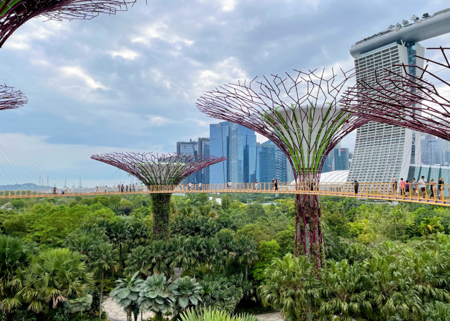
We’ve been to the lush oasis of Gardens by the Bay countless times, but we can never get enough of the air-conditioned conservatories — especially in Singapore’s humid heat. The Cloud Forest and Flower Dome are two of our favourites, thanks to their ever-changing exhibitions. Oh, and don’t miss out on attractions like Floral Fantasy, OCBC Skyway, and Supertree Observatory — just know that these are ticketed.
For free adventures, get moving at the Active Garden, spot aquatic life around the Dragonfly and Kingfisher Lakes, let the little ones splash around at the Children’s Garden, or take a tranquil stroll along the Kingfisher Wetlands Trail. Over at the Sun Pavilion, you’ll come across a unique collection of desert plants, while the Supertree Grove is home to those iconic towering structures. Don’t miss the dazzling Garden Rhapsody light and sound show at night (7.45pm & 8.45pm)!
Best for: Admiring gorgeous displays of blooms and greenery
Park size: 101 hectares
Difficulty level: Easy
Sights to look out for: Flower Dome, Cloud Forest, Supertree Grove
How to get there: Gardens by the Bay is located at 18 Marina Gardens Drive
7. Kranji Marshes
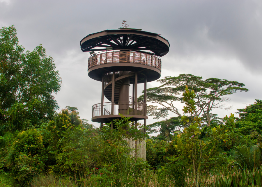
Kranji Marshes is a must-visit for wildlife enthusiasts looking to immerse themselves in nature. As one of Singapore’s largest freshwater marshes, it’s a haven for aquatic plants, insects, fish, and a variety of bird species.
For panoramic views, we recommend you head up the 10m-high Raptor Tower to gaze at the marshes and Kranji Reservoir. The easy 1km hike to the lookout point brings you through the park’s woodland areas, and you might even spot some rare birds, like the Common Moorhen or the Purple Swamphen.
Best for: A rustic trek to spot wildlife
Park size: 56.8 hectares (8 hectares accessible to the public)
Difficulty level: Easy
Sights to look out for: Birdwatching and the view from the Raptor Tower
How to get there: Kranji Marshes is located at 11 Neo Tiew Lane 2
8. Coney Island Park

Ditch beautifully manicured gardens for the undisturbed beauty of Coney Island Park. As one of the best places to hike in Singapore, this Punggol hangout offers a truly rustic walking experience. It typically takes us about two hours to explore the 3.6km route, passing by sandy beaches, mangroves, grasslands, and coastal forests. P.S. spot Pulau Ubin in the distance at the West Promenade!
The nature escape is also home to plenty of flora and fauna like tree-climbing crabs, woodpeckers and lovely casuarina trees. Our little ones have enjoyed the Casuarina Exploratory play area featuring wooden structures and bridges. If you’re keen to learn more, sign up for the two-hour guided tours on selected Saturday mornings in March, June, September and November.
Best for: Walking amidst untouched beauty
Park size: 81 hectares
Difficulty level: Easy
Sights to look out for: Casuarina trees and the Casuarina Exploratory play area
How to get there: Coney Island Park is located beside Punggol Promenade Nature Walk
9. Rifle Range Nature Park

Opened in November 2022, Rifle Range Nature Park is Singapore’s first net-positive energy green space. Formerly the site for Sin Seng Quarry, the area has been transformed into a stunning sanctuary with bridges, rugged trails, and a breathtaking lookout point perched on a granite cliff.
On our visit, we took a scenic elevated stroll along Gliders Boardwalk, roamed free on the Forest Exploration Trail’s play area, spotted one of the city’s few natural freshwater streams on the Banyan Trail, and hiked up the steeper Colugo Trail for panoramic views of the quarry wetland.
Best for: Cool cliffside views
Park size: 66 hectares
Difficulty level: Easy to moderate
Sights to look out for: Quarry wetland views
How to get there: Rifle Range Nature Park is located at 126 Rifle Range Road
10. Changi Bay Park Connector
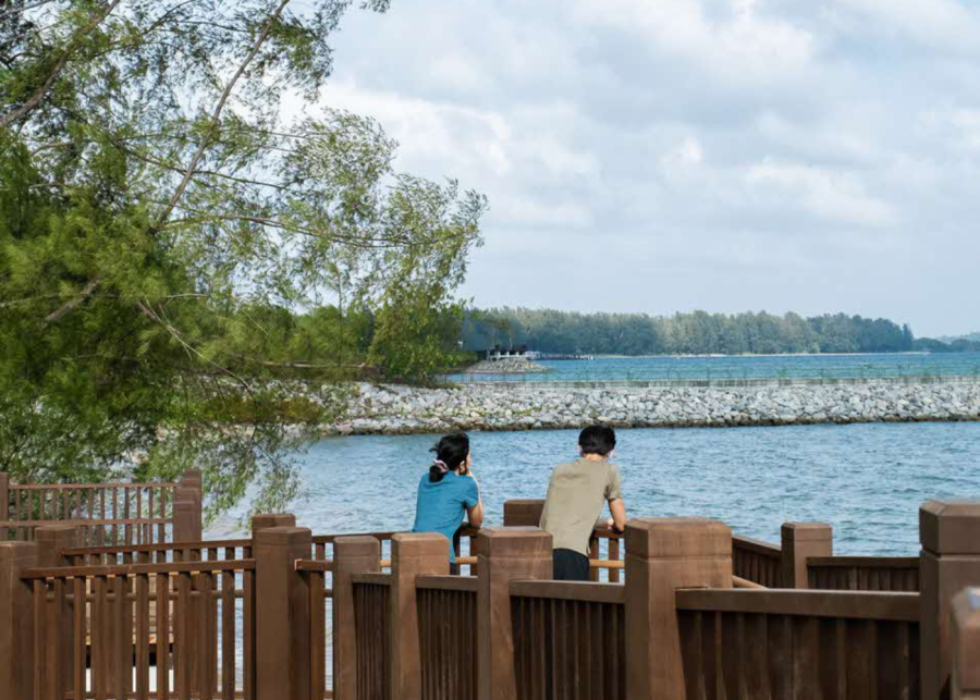
Part of the Round Island Route’s eastern corridor, Changi Bay Park Connector is a scenic link between Changi Beach Park and the East Coastal Park Connector Network. We stopped by for a romantic stroll and took a breather at the boardwalk for Insta-worthy waterfront views. Oh, and K-drama fans, you can immerse yourself in cool Jeju Island vibes at this lush green escape.
Best for: Slow, scenic strolls
Hiking distance: 3.6km
Difficulty level: Easy
Sights to look out for: Admire the waterfront sunrise view from the pavilion at Changi Bay Point
How to get there: Changi Bay Park Connector is located along Aviation Road
11. Pasir Ris Park

Up for an east-side adventure? Make your way to Pasir Ris Park. We joined the crowds and spotted families flocking here for barbecuing, fishing, camping, cycling, and fun times at the multiple playgrounds. Hiking along the 10km nature trail, we traiped across the mangrove forest, kitchen garden and butterfly garden over a couple of hours. Highlights along the way include a birdwatching tower, a scenic jetty, and loads of flora and fauna.
Best for: A family day out with playgrounds and activities along the way
Hiking distance: 10km
Difficulty level: Easy
Sights to look out for: Mangrove forest
How to get there: Pasir Ris Park stretches from Pasir Ris Road to Jalan Loyang Besar
12. Thomson Nature Park

We love Thomson for its quaint cafes and prata spots, which are perfect for lunch after you’ve explored this hiking trail in Singapore. Bringing the history of a former Hainanese village to life, the tranquil Thomson Nature Park boasts easy trails stretching across more than 3km. It’s great for beginners and couples who want a relaxing morning walk.
Keep an eye out for heritage sites along the Ruins and Figs Trail, and take in the peaceful freshwater habitat on the Stream and Ferns Trail. If you’re lucky, you might catch a glimpse of the critically endangered Raffles’ Banded Langur, as the park is a conservation site for this primate.
Best for: A quiet, easy walk amidst nature
Park size: 50 hectares
Difficulty level: Easy
Sights to look out for: Ruins of the former Hainanese village
How to get there: Thomson Nature Park is located between Old Upper Thomson Road and Upper Thomson Road

13. Bukit Batok Nature Park

Bukit Batok Nature Park offers hiking trails that take you past beautiful views and the tranquil waters of an abandoned quarry. We recommend it for a peaceful walk, as you can enjoy plenty of scenic rewards along the trail that’s under 4km, including the majestic quarry cliff. P.S. keep an eye out for the WWII memorial plague along Lorong Sesuai.
Best for: Enjoying breathtaking quarry views
Park size: 36 hectares
Difficulty level: Easy to moderate
Sights to look out for: Quarry, WWII memorial
How to get there: Bukit Batok Nature Park is located along Bukit Batok East Avenue 2 and Bukit Batok East Avenue 6
Where to go hiking in Singapore: Hikes that will make you sweat
14. The Southern Ridges
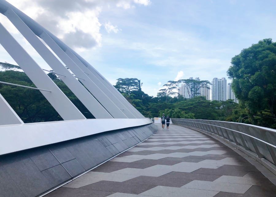
Stretching 10km across Singapore’s southwest, this scenic connector trail links five beautiful parks, making it a must for urban explorers. We’ve hiked it multiple times when we’re up for a challenge. Passing through Mount Faber Park, Telok Blangah Hill Park, HortPark, Kent Ridge Park, and Labrador Nature Reserve – each place offers a unique slice of greenery and deserves its own pitstop. Tip: depending on which Southern Ridges route you choose, the adventure will take you anywhere from three to five hours, so come prepared for a workout.
Highlights we love include the view from Mount Faber’s peak, the charming design of Henderson Waves bridge, the lush Forest Walk, and the quaint gardens at HortPark. But if you run out of steam during the walk, feel free to hop off and fuel up at the nearest food spot. We recommend the mid-way pitstop Canopy Hortpark for a pet-friendly garden cafe experience.
Best for: A picturesque trail across parks
Hiking distance: 10km
Difficulty level: Moderate to challenging
Sights to look out for: Henderson Waves bridge and Mount Faber peak
How to get there: To trek The Southern Ridges, start from Mount Faber Park, Kent Ridge Park, or Labrador Nature Reserve
15. MacRitchie Reservoir Park

Picture this: Peaceful tropical scenery, tranquil pathways, calming waterfront views, and gentle breezes greet you as you enter the park. MacRitchie Reservoir is one of the best places to hike in Singapore, and we keep coming back to this popular spot for morning dates and solo strolls.
If you’re in the mood to saunter by the water, go for the easy, scenic 4.8km route and stroll along the Chemperai and Jering Boardwalks. Want to challenge yourself? Take the four-hour 11km walk to hike the boundary of the entire nature reserve.
Or, head to the quiet Windsor Nature Park nearby and climb the famous 7km TreeTop Walk. We were tempted to give up during the endless uphill trek, but we stayed the course and were rewarded at the peak with a suspended walkway offering a breathtaking bird’s-eye view of the forest canopy.
Best for: Wildlife sightings and boardwalk views
Hiking distance: 20km
Difficulty level: Easy to challenging
Sights to look out for: The view from above at the TreeTop Walk
How to get there: There are multiple starting points at MacRitchie Reservoir Park, but the most common one is the entrance via Lornie Road
16. Rail Corridor

Once a railway track, the Rail Corridor is a scenic walking trail. It winds from the old Tanjong Pagar Railway Station in Outram to the Kranji area in the north. On the central route, you’ll pass through lush spots like the Singapore Quarry, Hindhede Walk, and Bukit Timah Railway Station.
If you’re at the southern end, you’ll trek past Holland, Buona Vista, Gillman, and Bukit Merah. Along the way, explore grasslands, streams, and marshes teeming with wildlife.
Best for: Hiking along lush, changing landscapes
Hiking distance: 24km
Difficulty level: Moderate
Sights to look out for: Upper Bukit Timah truss bridge and Bukit Timah Railway Station
How to get there: Start your Rail Corridor trek at Kranji Node near Kranji MRT station or the entrance near Hillview MRT station
17. Fort Canning Park
The historic hill of Fort Canning Park is packed with fascinating stories and cultural gems waiting to be uncovered as you hike up to the top. We recommend you take a step into the past at Battle Box, a hidden underground WWII bunker that offers a gripping history lesson (it’s worth the ticketed entry, trust us).
But the park’s past goes even further – archaeological digs have revealed that it once housed a kingdom home to the royal palace of ancient Malay rulers. Oh, and don’t miss the Sang Nila Utama Garden! With its tropical beauty and intricate structures, it made us feel like we were whisked away to Bali. The Spice Garden is also worth checking out to get a whiff of plants like basil, tamarind, cinnamon and nutmeg. For a little rest stop, head to Tiong Bahru Bakery or French restaurant Le Jardin to fuel up.
Best for: Uncovering history and hidden gems
Park size: 18 hectares
Difficulty level: Moderate
Sights to look out for: Fort Gate, Fort Canning Lighthouse, and the Instagram-famous Fort Canning Tree Tunnel
How to get there: Fort Canning Park is bounded by Hill Street, Canning Rise, Clemenceau Avenue and River Valley Road
18. Dairy Farm Nature Park

After trekking the 2.2km Wallace Trail at Dairy Farm Nature Park, we discovered it’s not as manicured as other walking paths. Our tip? Gear up in covered shoes with long pants and tops to embark on the rustic journey through muddy paths and challenging terrain. It’s popular with mountain bikers, but hikers can easily navigate the route, too.
So, what makes it worth the hike? The two quarries! We enjoyed admiring the view of the magnificent rock cliffs at Dairy Farm Quarry and the picturesque lake at the Singapore Quarry.
Best for: A rugged hike
Hiking distance: 2.2km
Difficulty level: Easy to moderate
Sights to look out for: Dairy Farm Quarry and Singapore Quarry
How to get there: Dairy Farm Nature Park is located at 100 Dairy Farm Road
19. Mount Faber Park

This may be one of Singapore’s oldest parks, but it’s still a great place to hike. We love making the trek up to Faber Point to enjoy gorgeous panoramic sights. Start at the Marang Trail near HarbourFront MRT station and continue to Faber Walk. Along the way, you’ll be rewarded with views of the Southern Islands.
At Mount Faber Peak, take a well-deserved break and enjoy a meal at restaurants like Arbora or Dusk. Tip: stay on for incredible sunset views or hop on a cable car to experience sky dining. To continue trekking, you can easily hop on the Southern Ridges trail.
Best for: An uphill climb and panoramic sights
Park size: 56 hectares
Difficulty level: Easy to moderate
Sights to look out for: Views from Faber Point
How to get there: Mount Faber Park is located at the junction of Kampong Bahru Road and Telok Blangah Road
20. Pulau Ubin

If paved paths and treetop walks aren’t your thing, hop on a bumboat and journey back in time to Pulau Ubin. You’ll get a taste of kampong life and a throwback to 1960s Singapore. It’s the best place to hike in offshore Singapore, as you can embark on a rustic adventure with activities like kayaking, camping, fishing, and cycling.
We recommend you lace up your boots and head to the Chek Jawa wetlands to explore mangrove swamps and coastal forests. Stroll along the Mangrove Boardwalk and climb Jejawi Tower for an aerial view of the island, or hike up Puaka Hill for views of Ubin Quarry. It’s a wild adventure through nature, so don’t forget to refuel at one of the eateries or provision shops in the main village afterwards.
Best for: An undisturbed island escape
Island size: 10.2 sq km
Difficulty level: Moderate
Sights to look out for: Chek Jawa wetlands, Puaka Hill
How to get there: Take a 10-minute bumboat ride from Changi Point Ferry Terminal to Pulau Ubin; operating hours are typically from 7am to 7pm and tickets cost about $4 per person
Where to go hiking in Singapore: Challenging paths and steep slopes
21. Bukit Timah Nature Reserve

It’s no Everest, but trust us – your calves will feel the burn as you climb Bukit Timah Nature Reserve’s popular hiking trail in Singapore. (We’ll admit, we were a little breathless by the time we made it to the summit.)
Standing at 163 metres, Bukit Timah Hill is the city’s highest natural peak. The three paths – which range from 1.2km to 3km – offer steep, short routes for those with a burst of energy and longer options through tropical scenes. Sadly, we couldn’t see much of a view from the top, but we were well-rewarded by a sense of achievement.
Best for: A steep climb to the top
Park size: 163 hectares
Difficulty level: Moderate to challenging
Sights to look out for: Flora and fauna along the climb
How to get there: Bukit Timah Nature Reserve is located at the end of Hindhede Drive
22. Coast-to-Coast Trail

The Coast-to-Coast (C2C) Trail is the ultimate challenge for avid hikers and adventurers. Spanning 36km, it takes you on a journey across Singapore, from Jurong Lake Gardens in the west to Coney Island Park in the northeast. Along the way, you’ll pass through various parks and connectors.
Oh, and don’t worry about completing the whole route in one go – there are 10 checkpoints at various spots like Bukit Batok Nature Park, Sengkang Floating Wetland, and Rower’s Bay Park, making it perfect for a multi-day adventure. Tip: download the C2C Mobile App to plan your hike, track your progress, and learn about the local wildlife you might encounter.
Best for: A challenging journey across Singapore
Hiking distance: 36km
Difficulty level: Challenging
Sights to look out for: All the parks along the way
How to get there: Start from either end of the Coast-to-Coast Trail (Jurong Lake Gardens or Rower’s Bay Park), or hop on at any of the checkpoints
23. Keppel Hill Reservoir

Want to immerse yourself in eerie, abandoned vibes? It’s believed that the forgotten Keppel Hill Reservoir was left to decay in the 50s after a series of drownings, only to be rediscovered in 2014. Grab your adventurous pals and venture through desolate paths to find the quiet reservoir. Across two hours, your journey will take you past the neglected WWII-era Seah Im Bunker, steep hills, the decrepit No. 11 Keppel House, and a Japanese tomb.
But take note that there’s no official trail, so don’t wander around without proper safety measures. Proceed with caution and wear long pants, long-sleeved tops and solid hiking boots as some areas are overgrown and dense.
Best for: An off-the-beaten-path trek
Difficulty level: Challenging
Sights to look out for: No. 11 Keppel House and the abandoned Japanese tomb
How to get there: Start your journey to Keppel Hill Reservoir from Seah Im Carpark
Now, who’s ready to check out these hiking trails in Singapore?
Frequently Asked Questions
Are hiking trails in Singapore suitable for beginners?
Yes! Many trails in this list are beginner-friendly, with easy walking paths and minimal elevation. Parks like Sungei Buloh Wetland Reserve, Bishan-Ang Mo Kio Park, Gardens by the Bay, and Rower’s Bay Park are great starting points if you’re new to hiking or just want a relaxed stroll.
Which hiking trails in Singapore are best for families and kids?
Family-friendly picks include Bishan-Ang Mo Kio Park, Jurong Lake Gardens, Pasir Ris Park, and Coney Island Park. These spots have wide paths, playgrounds, rest areas, and nearby amenities, making them ideal for little legs and picnic breaks.
What should I wear when hiking in Singapore?
Light, breathable clothing and comfortable walking shoes are key. For easy trails, sneakers will do, but for rugged or muddy routes like Dairy Farm Nature Park or Bukit Timah Nature Reserve, covered shoes with good grip are recommended. Don’t forget sunscreen, a hat, and plenty of water.
Are there hiking trails with wildlife sightings?
Absolutely. Sungei Buloh Wetland Reserve, Kranji Marshes, MacRitchie Reservoir Park, and Pulau Ubin are hotspots for spotting birds, otters, monitor lizards, and other native wildlife. Remember to keep a safe distance and never feed the animals.
Which hikes are best if I want a proper workout?
If you’re looking to break a sweat, head to Bukit Timah Nature Reserve, The Southern Ridges, MacRitchie’s longer routes, or tackle the Coast-to-Coast Trail. These hikes feature longer distances, steep climbs, or both.
Do I need a permit or guide to hike in Singapore?
Most hiking trails in Singapore are free and open to the public, with no permits required. However, for off-the-beaten-path areas like Keppel Hill Reservoir or guided experiences in places like Pulau Ubin, it’s best to go with experienced companions or join official guided walks for safety.